
ANALYTICAL SYSTEM OF REAL ESTATE OF UKRAINE
Cartographic platform for effective real estate management


This is a cartographic platform, the main purpose of which is to collect, record, accumulate, process and display information about real estate objects of the territorial community, the region and the country in general
The platform enables:
perform an automated search for real estate information;
receive up-to-date information on the dynamics of real estate value changes depending on specific parameters: location, type and material of the building, condition, demand and activity of the real estate market;
view data about objects: primary, secondary, commercial real estate, real estate intended for mixed use, etc.;
keep records of leases, landlords, contracts;
visualize rented premises and their current status;
to carry out operational control of income and expenses related to the rental of each specific real estate object;
make calculations of utility payments, issue invoices;
to analyze existing and plan potential real estate objects using design and estimate materials and other working documentation previously entered into the system;
to form a single point of access of operational services to relevant information about real estate objects, where any problem needs to be solved (repair, reconstruction, improvement).


The cartographic platform stands out
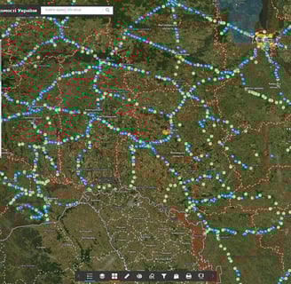
displays real estate objects on the map
visualizes information about each type of object
contains a photo gallery
stores a detailed description and key characteristics (passports), coordinates and many other information important for decision-making
The analytical system is easy to use
☑ Primary and secondary real estate
☑ Specialized and non-specialized real estate
☑ Objects of unfinished construction
☑ Real estate damaged by war
☑ Commercial real estate
☑ Industrial real estate
Typical structure of the system
map information database (display of real estate objects)
a subsystem of operational inspection of the state of real estate objects
subsystem of monitoring and registration of appeals, carrying out repairs
A set of layers of the geographic information system:
☑ The software has an intuitive interface, the software is built on the basis of modern geoinformation technologies
☑ There is a control panel for data sets, separate map resources, layers of spatial information, etc
☑ System support does not require programming knowledge, there is no need to keep programmers in the customer's staff
☑ Building new system modules and connecting new users does not require additional software development
☑ Information is stored on the server and in the database, so maximum security is achieved, including data with limited access
☑ Regulated access to information resources thanks to the assignment of roles to system users: administrator, operator, editor
☑ System deployment includes supply of hardware and software, filling of databases, training of specialists to keep the system up-to-date, technical support